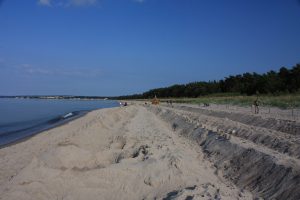
The Wittow Beach on Rügen
The peninsula - known in German as Halbinsel - Wittow is located in the northeastern part of the island of Rügen. It is surrounded by the Baltic Sea and can only be reached overland via the Jasmund peninsula. There is also a ferry service to Wittow. The beach at Wittow is the longest on Rügen, stretching for 8 kilometres. It is not particularly wide - at its broadest point, the beach measures roughly one and a half kilometres. Since most of the land is privately owned, the Wittow beach tends to be quiet and uncrowded. Visitors are welcome to explore the publicly accessible paths throughout the area.
Wittow Beach: Largely in Private Ownership
 The majority of Wittow is privately owned and therefore not freely accessible to the general public. Part of the peninsula falls within the Vorpommersche Boddenlandschaft National Park, which is open to visitors. Many travellers to Rügen take a day trip to Wittow to enjoy the beautiful natural scenery. The northernmost point of Wittow is the Gellort, situated approximately one kilometre northwest of Kap Arkona. At the base of the Gellort lies the Siebenschneidenstein, the fifth-largest erratic boulder on Rügen. The landscape of Wittow is defined primarily by steep cliffs in the north and the lower-lying Bodden landscape in the south. Since Wittow is exposed to the wind from nearly every direction, the peninsula is also known as Windland - the Land of Wind.
The Best-Known Villages on Wittow
On the Wittow peninsula, you will find the communities of Breege, Putgarten, Dranske, Wiek, and Altenkirchen. These villages formerly belonged to the municipality of Wittow. Today, they fall under the municipality of Nord Rügen. For nature lovers, a visit to Wittow is highly recommended. The climate is mild rather than hot - the average annual temperature on Wittow is just under 8 degrees Celsius, with an average annual rainfall of over 500 mm.
Practical information
- Address
- Wittow Peninsula, northern Rugen (near Dranske and Kap Arkona)
- Opening hours
- Freely accessible.
- Price
- Free (local beach fee/Kurtaxe may apply).
- Visit duration
- Half to full day
- Best time
- Summer for swimming; it is often windy here, making it ideal for wind- and kitesurfers.
Location on Rügen
Frequently asked questions
Where is the Wittow beach located?
On the Wittow Peninsula, the northernmost part of Rügen. Well-known beaches are found near Dranske and in the vicinity of Kap Arkona.
How do you get to Wittow?
By land, you can reach Wittow via the Jasmund peninsula and the narrow isthmus known as the Schaabe. A faster option is the small car ferry on the Schaprode-Wittow route.
What makes the beaches of Wittow special?
They are wide, unspoiled, and far quieter than the fashionable seaside resorts in the south. The wind makes them popular with wind- and kitesurfers, and you will also find Kap Arkona with its historic lighthouses nearby.
Tickets & tours
Book the best activities, tours and tickets in advance.